information
Despite Bircza’s small size and relative obscurity, I have come across a number of maps of this area in the course of my genealogy work. One map, a military-scale map of the Dobromil Region (Pas 50 Słup 35) printed in 1938 by the Wojskowy Instytut Geograficzny, is undoubtedly the most precise and most valuable. I have scanned the relevant parts and broken them up into sections which one can view below, and which can always be accessed by the ‘interactive map’ menu on the right sidebar of every page on the Bircza Online website.
A number of useful contemporary maps are available at the official Bircza website’s
map page. These and other maps are listed on the right side of this page and clicking on the name will load the map. Please remember that these maps are reproduced here for private genealogy use, since many are copyrighted by their makers and cannot be used for commercial use.
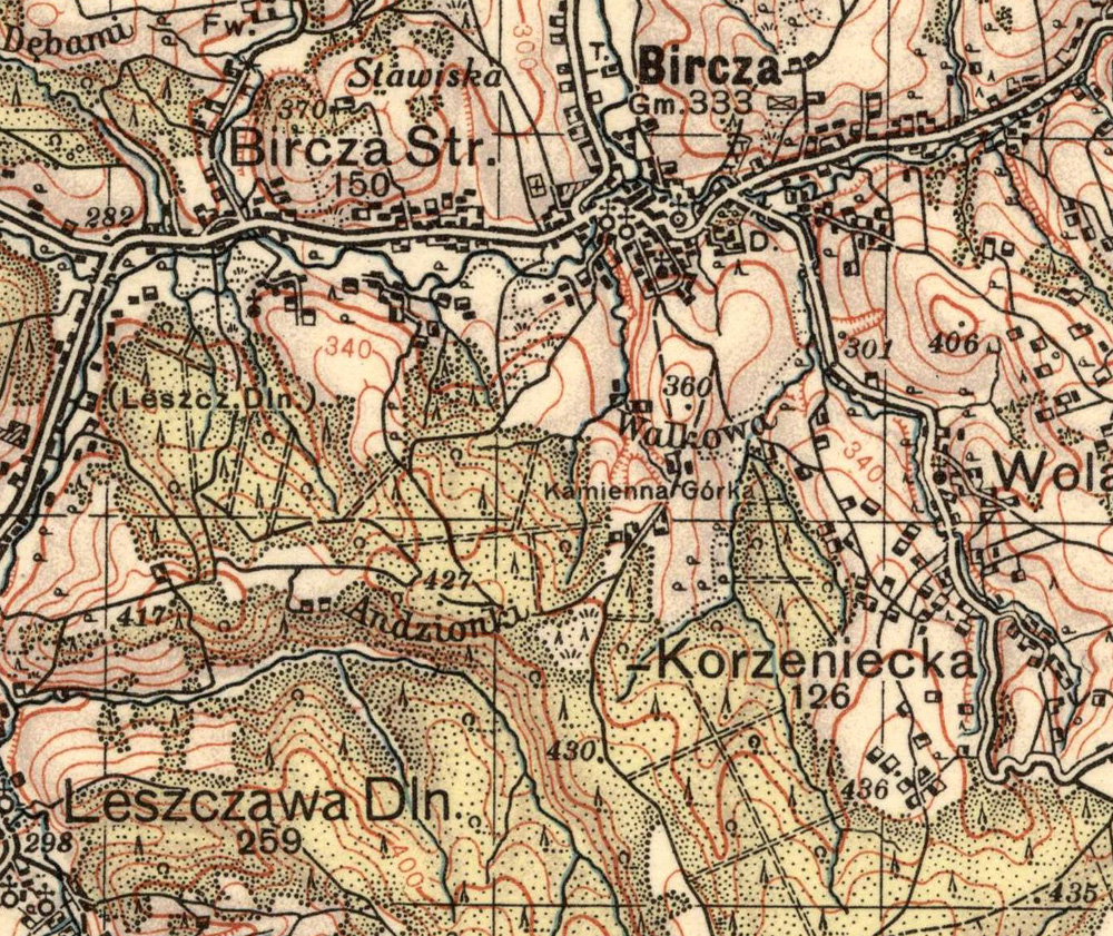
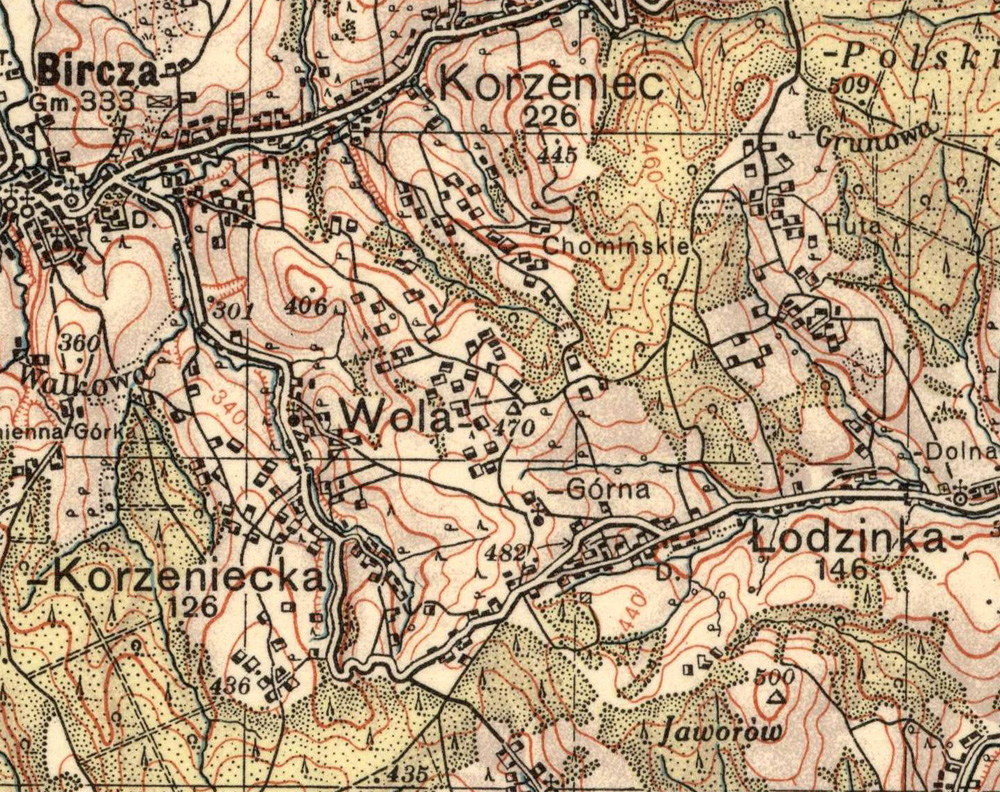
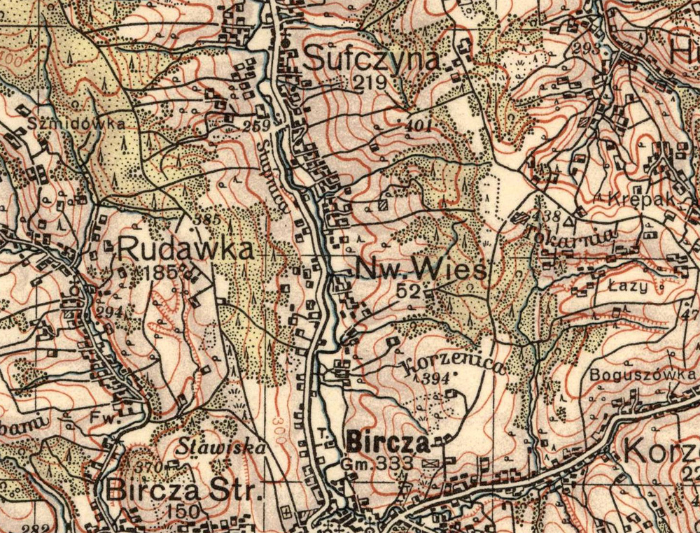
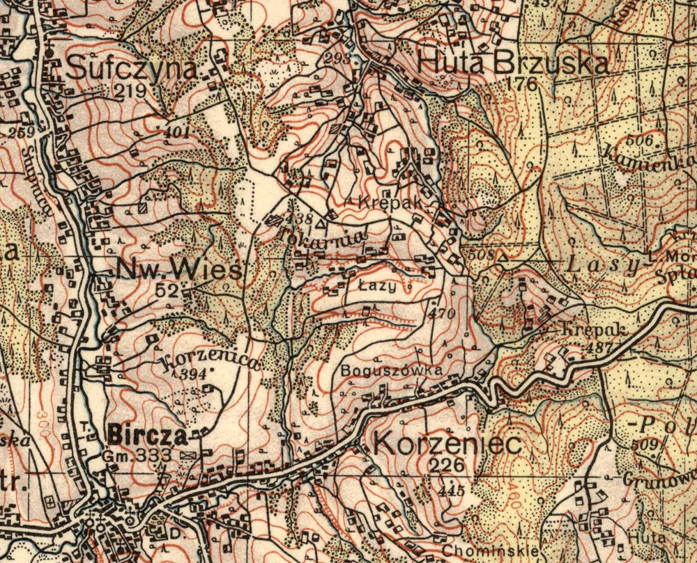
The Wojskowy Instytut Geograficzny (WIG; ‘Military Institute of Geography’) map is a military-scale map of the Dobromil Region (Pas 50 Słup 35). Its scale is 1 : 100 000 (1 centimetre = 1 kilometre). Each map is marked with horizontal and vertical numbers that work like latitude / longitude lines, using the same outlay as the original map. To view a village or town, either click its name in the index below and find it using the co-ordinates listed, or click directly onto the large map below to zoom in on certain areas. Some locations can be found in more than one map, and the listing below is usually the most descriptive for the specific village. Recently, the entire WIG series has been placed online, with hundreds of detailed maps of Poland from the pre-1939 period (as well as post-Second World War). For more information, see the WIG online archive.
| Wojskowy Instytut Geograficzny map index |
| Place Name |
Hor. # |
Vert. # |
Place Name |
Hor. # |
Vert. # |
| Bircza area |
- |
- |
Bircza area |
- |
- |
| Andztonki |
41½ |
33½ |
Krępak |
46½ |
37 |
| Boguszówka |
45 |
37 |
Łazy |
45½ |
37 |
| Chominskie |
43 |
38 |
Łeszcz Dolna |
42½ |
32 |
| Górna |
42 |
38 |
Leszczawa Dolna |
40 |
32 |
| Grunowa |
44 |
39½ |
Łódzinka |
41½ |
39 |
| Huta Brzuska |
48 |
38 |
Nowa Wieś |
46 |
35 |
| Kamienna Górka |
42 |
33½ |
Rudawka |
46 |
33 |
| Korzenica |
45 |
37½ |
Stara Bircza |
44 |
33 |
| Korzeniec |
44½ |
37 |
Sufczyna |
47½ |
35 |
| Korzeniecka |
41 |
35 |
Wola |
42½ |
37 |
Click on the map or the index above to zoom to a more detailed map below. Click here to see the full-size version of this map.
Click here to see a larger version without line marks.
Click here to see a larger version without line marks.
Click here to see a larger version without line marks.
Click here to see a larger version without line marks.
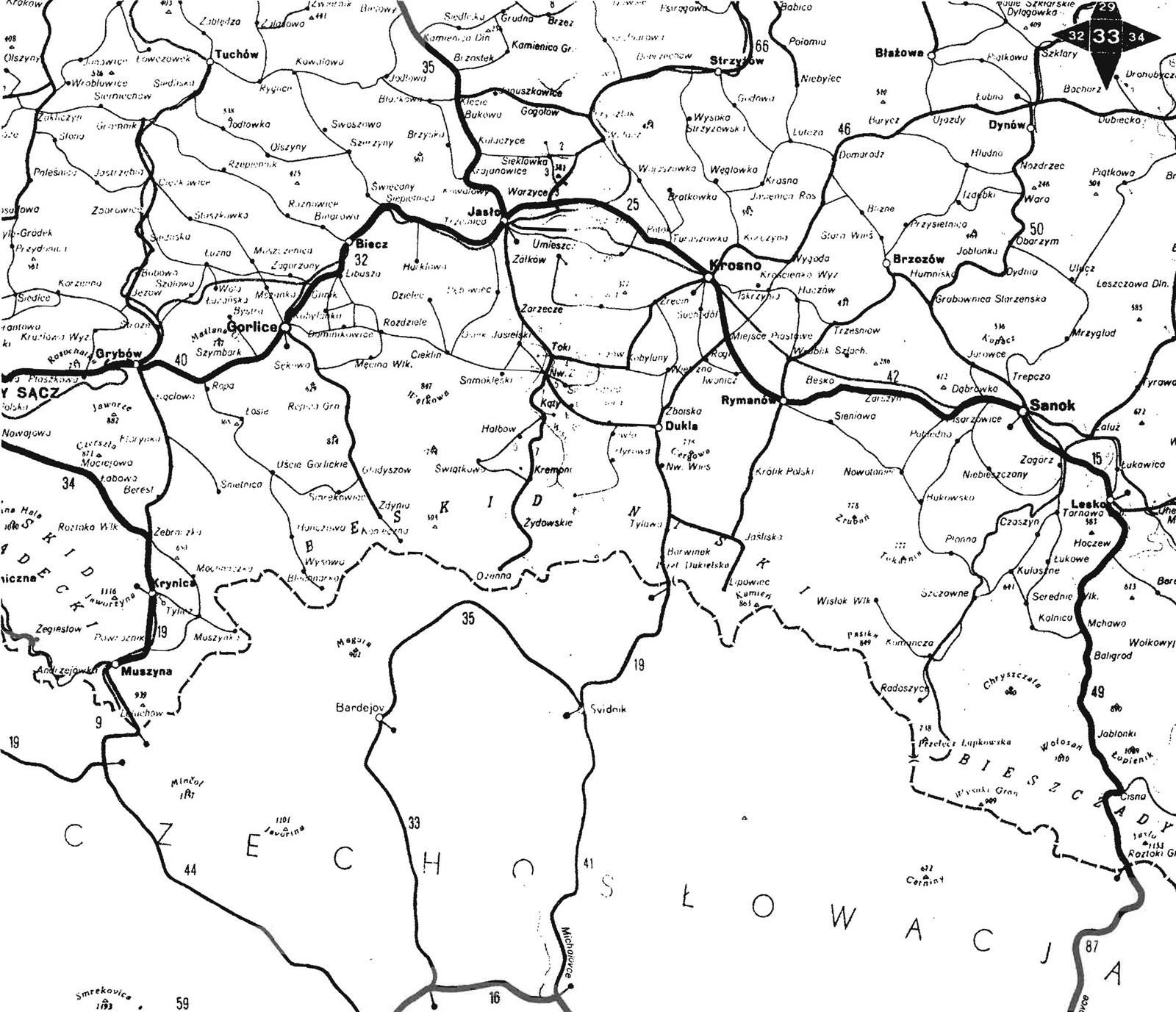
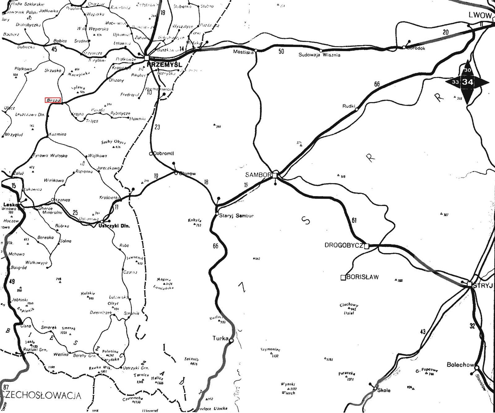
This map is from an atlas printed by the Państwowe Przedsiębiorstwo Wydawnictw Kartograficznych (PPWK; ‘Polish Cartographic Publishing Company’), in 1959. The volume has 155 pages with 34 individual sections of Poland shown on a 1 : 500,000 scale (1 centimetre = 5 kilometres). It also has an information page between each map listing phone numbers of hotels, hospitals, etc. for the major cities in the area shown. The selections here are from pages 33 and 34, and show Bircza in relation to Przemyśl, Sanok, Krosno, Rymanów, Ustczyki Dolna, and other towns in the region.
During the course of my correspondence with fellow Bircza area researcher Betty Kemp, who is looking for details on her grandfather Wojciech Huczko, in Posada Olchowska, and her grandmother's family (Andrzej Pich), in Siemuszowa (both near Sanok), I received this black-and-white reproduction, made from the full-colour atlas. To view more detail, click on a section of the map below, or simply scroll down the page. For more information on the map, please contact contact me or Betty.
The large map below is a combination of both pages 33 and 34; to see a scaled and detailed map of the area in the centre, please view the other maps below. I have outlined Bircza in red.
Click on the map above to zoom to a more detailed map below. Click
here to see the full-size version of this map.
Click
here to see the full-size version of this map.
Click
here to see the full-size version of this map.
To contribute information or make contact with Bircza Online, please use this form below, or email bircza@reproots.org.
|
![[coming soon: a total redesign of the website!]](http://images.reproots.org/redesign.jpg)
![[bircza online header]](http://images.reproots.org/header-bircza.jpg)
![[wig regional map of bircza]](maps/wig.region-resized.jpg)
![[ppwk regional map of bircza]](maps/ppwk-full.resized.jpg)
![[Państwowe Przedsiębiorstwo Wydawnictw Kartograficznych (PPWK) map, 1959; area west of Bircza]](maps/ppwk-33.resized.jpg)
![[Państwowe Przedsiębiorstwo Wydawnictw Kartograficznych (PPWK) map, 1959; Bircza, its environs, and the area east]](maps/ppwk-34.resized.jpg)
![[present-day poland map]](maps/poland.gif)
![[bircza.pl topography map, 2006]](maps/birczamaps.topog.jpg)
![[bircza.pl administrative area map, 2006]](maps/birczamaps.area.gif)
![[wojskowy instytut geograficzny map, 1938]](maps/wig.region.jpg)
![[chris wozniak’s map, 1998]](maps/wozniak_map.jpg)
![[bircza.pl area roads map, 2006]](maps/birczamaps.roads.jpg)
![[bircza.pl street map, 2006]](maps/birczamaps.ulice.jpg)
![[państwowe przedsiębiorstwo wydawnictw kartograficznych (PPWK) map, 1959]](maps/ppwk-full.jpg)